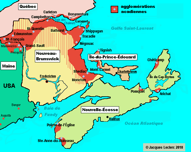
The Gaspésie was my favourite stop on our Canadian road-trip! The Gaspésie is an encircled peninsula where ocean, mountains and wilderness come together. Indeed, it is this piece of land that looks like a small paw when you look at the map of Quebec. Its name comes from the Micmac “gespeg” which means “where the land ends”, and it is true that arriving at the extremity of this piece of land, I am surprised to think that indeed, facing the Atlantic Ocean, the impression of being at the end of the world is perceived.
We spent a few days discovering the Gaspesian land and its many assets that make it a popular destination for Quebecers and a destination that is as big as Belgium! As soon as we arrived in Matane with the ferry, we took route 132, which splits in two in the gaspésie to form an itinerant loop of about 885 kilometres. We decided to take the northern route of the island in order to arrive in the Bas-Saint-Laurent region while having seen the vast majority of the Gaspésie.
This route follows landscapes of sea, mountains but also bays and places turned towards nature and the forest. The Gaspésie is still very wild and nature is at the heart of this trip in this region. In order to make this article easier to discover, I will tell you in detail about the 5 regions that make up the Gaspésie and tell you about our adventures in each of them.

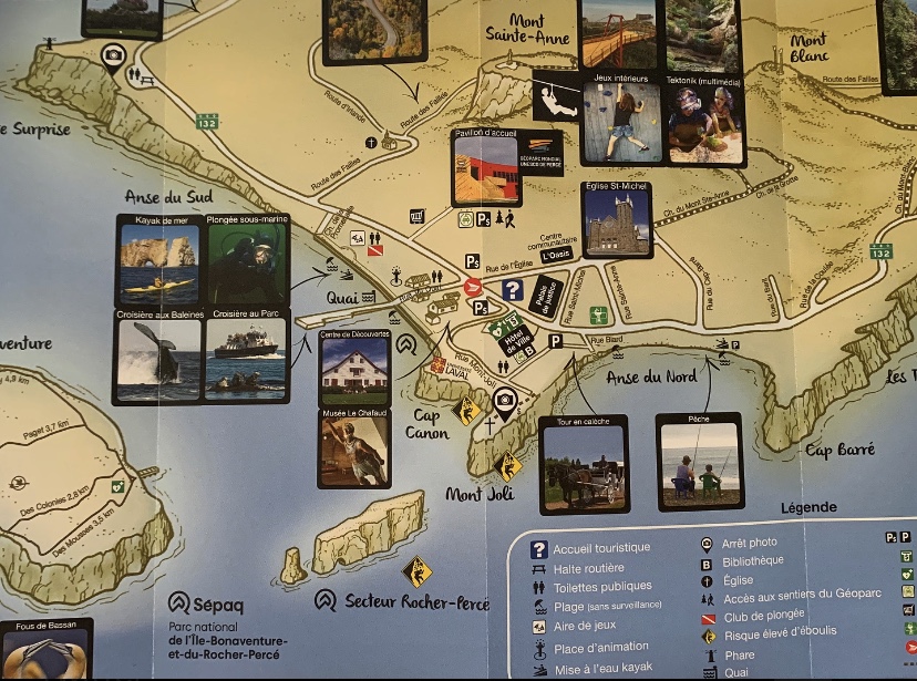
This map can be found on the official Gaspésie website.
The Coast

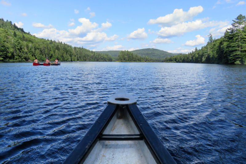
Sunset from the ferry, arriving in Matane around 9pm.
Along the shores of the majestic St. Lawrence River, it is in Sainte-Flavie that the Gapésie opens its doors to those who wish to visit its region. However, we arrived by ferry in Matane so we decided not to go down to this region. We spent the night in an Airbnb in Matane and then we gently headed to the next region, the Haute-Gaspésie. To tell the truth, we didn’t find it attractive to visit Matane or the other places in the region because other activities seemed better to undertake afterwards. It must also be said that we only had one week in the Gaspésie so we wanted to enjoy its nature and maritime landscapes more.
The HAUTE-GASPÉSIE
On its own, the Haute-Gaspésie has all the attractions sought after in the Gaspésie: the fauna and flora, the sea and the mountains. We devoured its 130 kilometres of shoreline where culture and magnificent landscapes mingle, and we also ventured inland, on an adventure in the famous Gaspésie National Park.
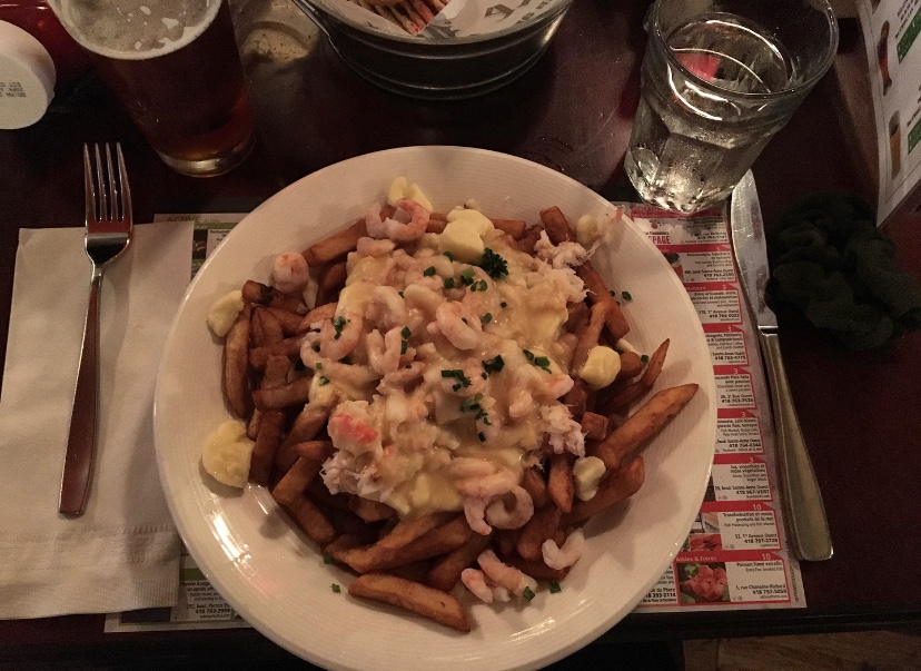
Sainte-Anne-des-Monts is the ideal place to sleep before going for a walk in the Gaspésie National Park since it is 17 km away from the park. We slept one night in a motel and the town itself is not very interesting. However, it was finally time to taste my first poutine (and not my last one, considering how delicious it was) at the Auberge Chez Bass which also serves as a hotel and where we wanted to spend the night, but the last room for our dates was booked a few minutes before our reservation (the hazards of booking on the spot).
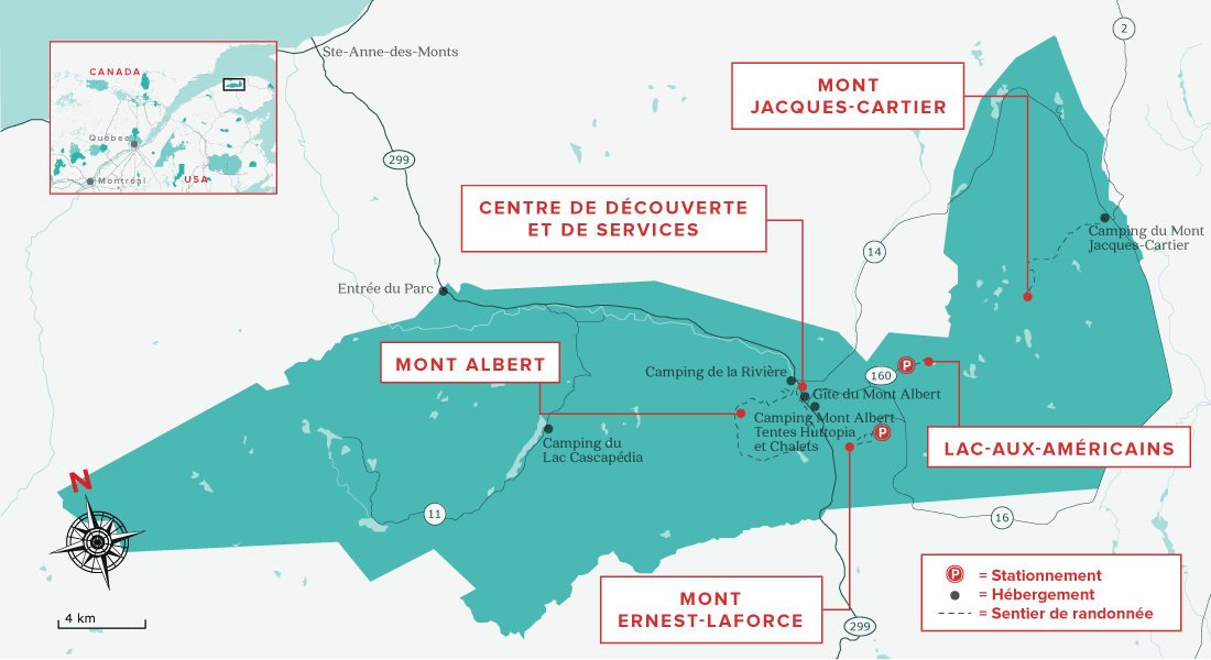
GASPÉSIE NATIONAL PARk
Second oldest national park in Quebec after Mont-Tremblant, which we didn’t have the opportunity to discover, the Gaspésie National Park is major hiking and ski touring destination. It provides access to an exceptional mountain environment that includes the second highest peak in Quebec: Mount Jacques-Cartier as well as 25 peaks over 1,000m with the Chic-Chocs and McGerrigle mountain ranges. The park presents itself as ” this sea of glacier-chiselled mountains is festooned with stone fields, high plateaus, ridges, and deep valleys whose wildlife and flora recall the Far North”.
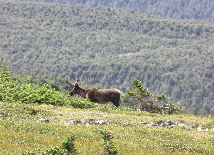
Indeed, this park is grandiose in its size, diverse beauty and impressive massifs that influence the climate, shape a landscape that is very different from other national parks visited and create a precious wildlife diversity with a tundra climate that is the habitat of a herd of woodland caribou, the last representatives of this species south of the St. Lawrence River.
ACTIVITieS
Like other national parks in Canada and around the world, the Gaspésie National Park is an incredible open-air playground where hiking is the number one activity. The park is huge and features 140 km of marked trails, many of which lead to summits. There are trails for all levels and of varying lengths.
If you have read the various articles on the parks in Quebec, at each park, we arrived with no idea of what activities to undertake. Always preferring the free ones, the ranger at the discovery and service centre, explained to us, after hearing our few desires, to do the Mont Jacques-Cartier hike. However, we had to hurry to get to the beginning of the hike. Start of the countdown, but why?
As I have already told you, this summit is the habitat of a caribou herd and there are restrictions on their preservation. Indeed, the presence of hikers can disturb the animals so it is forbidden to walk on the trail before 10:00 am and after 4:00 pm. In addition, you must park your car in a car park and then follow a ranger who will take you with his big yellow bus at the beginning of the hike. This shuttle is not free of charge, you will have to pay $7.50 per adult for the return trip.
So we were at the discovery and service centre, and the ranger explained that there is a departure every 30 minutes from 10 am to 12 pm. I do not, now, remember exactly what time it was but we had to get to the Mont Jacques-Cartier reception as quickly as possible to take the penultimate shuttle to enjoy a bit of the summit. What we hadn’t imagined was the road conditions to get there. Finally, the road is a big word. It’s a kind of track with varying sizes of stones! So we might as well say that with our rental car we weren’t going that fast and above all we were afraid of the state of the car after this road. The speed limit was 70 km/h but with our car, it was not possible given the condition of the track, so it was a race against time to get to the reception before the shuttle left.
We finally arrived 2 minutes before 11:30 am, I let my friend park and jumped out of the car to go and get the tickets from the reception desk at the ranger. I thought I had time to go to the toilet, but I didn’t have time for it! I’ll have to wait for the beginning of the hike after 10 minutes in the shuttle and do that in a small hut full of bugs… Aww, nature…
We found ourselves on the bus with about ten hikers, and the ranger explained to us the rules governing this hike. He also explained to us that we have to be very careful with our time because the last departure for the car park is at 4 pm. So for information, off-trail walking is forbidden during this hike.
“Keep your senses alert!
From here, you breathe the same air as he does.
Your footsteps land on the same stones.
If by some happy chance your eyes meet this beautiful animal,
greet him with eyes only, discreetly, crouching,
let the sovereign of the summits pass by!“
I recently found this quote, translated from French, which was currently written on a sign at the entrance to the trail and it perfectly summarizes the ranger’s recommendations.
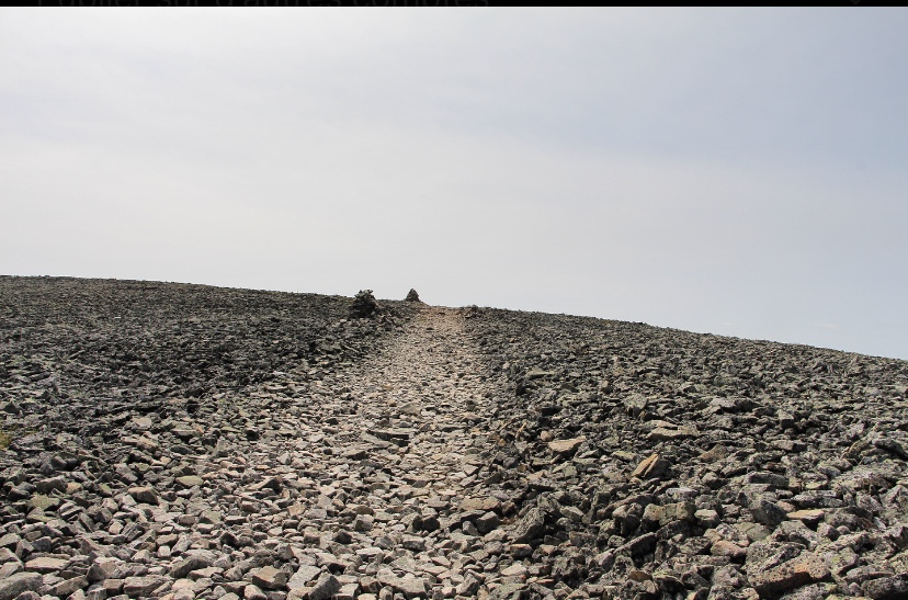
Finally, we could start walking, to arrive about 1:30-2 hours later at the summit, at more than 1’000 meters of altitude.
It’s a very tough climb on a rocky path, so be prepared your knees will be sore. However, the sun was there to enjoy the hike and then to discover that as we got higher, the vegetation was giving way to a more austere terrain.

Even though we had opened our eyes, there was still no caribou on the horizon, which was enough to make us a little desperate knowing that we had been going up for almost 2 hours. Afterwards, the slope was much less pronounced but was still difficult with a staircase of stone landings.
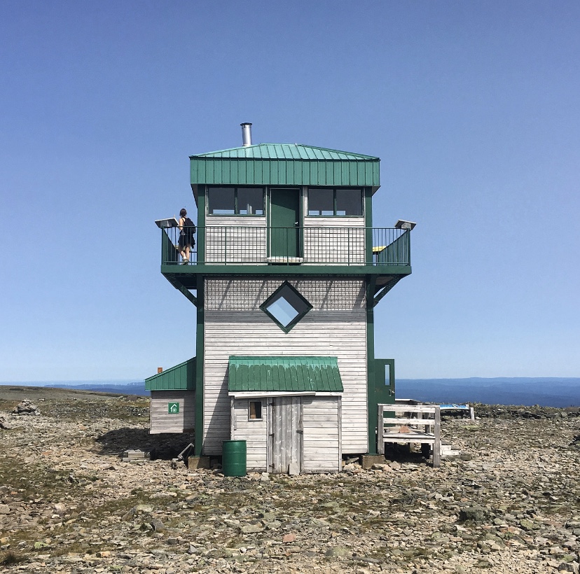
At the top, the temperature dropped a few degrees but the view was worth it. Indeed, we discovered a landscape quite different from the green forest where the shuttle dropped us off. We took the Caribou Trail which will lead us for 1 kilometre to the panoramic tower at the top.
Mont Jacques-Cartier offers arctic bioclimatic conditions at its summit covered by frost-bearing rocks and tundra. Thus, the 360° view is impressive and changes from what we had the opportunity to see since the beginning of our stay in Quebec. The diversity of this province fascinates me. We rested for a few minutes and ate our picnic on wooden chairs set up in the shape of deckchairs at the foot of the watchtower. We were hoping to see caribou, but at that moment, the counter was still at zero.


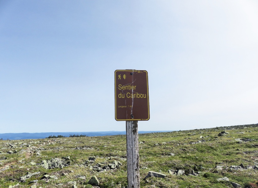
We will end up seeing two caribous and especially by following a few hikers on various trails at the summit, since each time we heard them say that they had seen the animals so we wanted to see them too (yes, we assumed we were following like sheep)… But well, it wasn’t the case, we lost a bit of time before going back down, but it allowed us to explore more of this tundra.

The descent will be a bit fast as we didn’t want to miss the last bus. It will also be partly on the buttocks considering the number of times we slipped because of these small rocks or simply by inadvertence we will say.
“stars” of the parks
The creation of this national park in 1937 was intended to permanently protect the caribou, making it the emblem of the park. Indeed, the large massifs of coniferous forest provide this animal with shelter and food. Seriously endangered, its observation allows the park rangers to ensure its protection and preservation while allowing it to live in the wild. The Gaspésie caribou population has been monitored annually since 1983, and in 2018, it is estimated that 75 caribou of this species remain in the wild.
DRIVING ON LIGHTHOUSE TRAIL
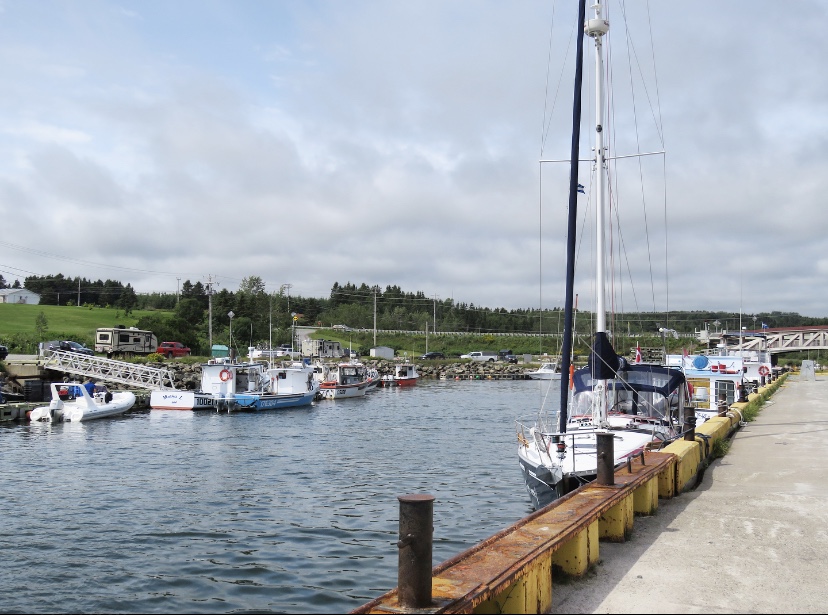
After sleeping in Sainte-Anne-des-Monts, we took advantage of being on Route 132 to take part in the Québec maritime lighthouse trail. Indeed, in Quebec and the Gapésie, there are many lighthouses because navigation has always been dangerous in the Gulf of St. Lawrence and the various bays of the peninsula. They have become real tourist attractions, and the north coast of the Gapésie allows visitors to admire many of these various witnesses to Québec’s maritime heritage. We first stopped at the hamlet of La Martre, famous for its beautiful red lighthouse, then at the Cap de la Madeleine lighthouse and finally at Pointe-à-la-Renommée.
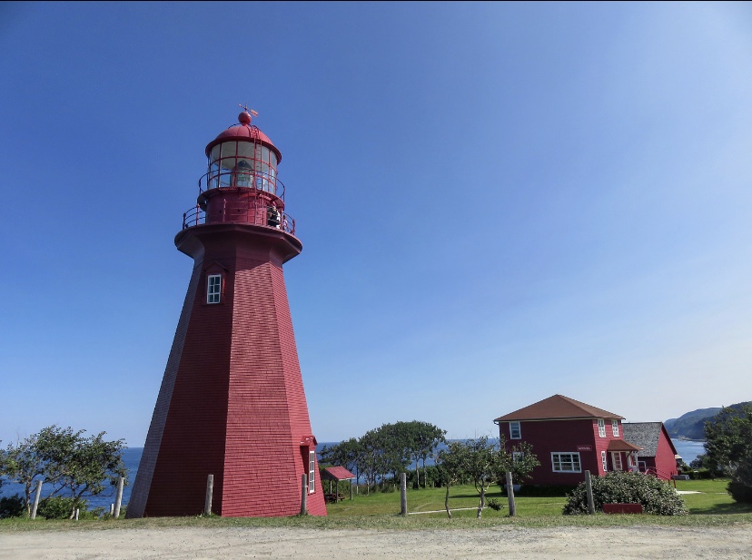
LA MARTRE
La Martre is an adorable fishing hamlet overlooking the St. Lawrence, which is known for one thing only, its magnificent lighthouse! It is a charming octagonal lighthouse with bright red shingles that was erected in 1906 and is still in service. Plan a simple stop to take a picture of it. There is a museum in the old keeper’s house but we didn’t think it was essential to understand the place.

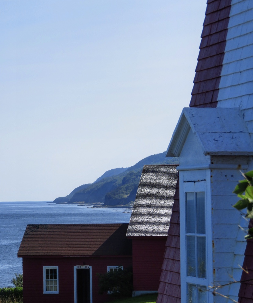
Thereafter, the coast becomes wilder as one approaches the Land’s End region, while the villages seem to be caught between the cliffs and the sea.

Land’s end
This region is the soul of Gaspésie, where the maritime character is most authentic. This is where the end of the world comes in, in Forillon Park, where the vertiginous cliffs are at their most beautiful.
CAP-DE-LA-MADELEINE LIGHTHOUSE
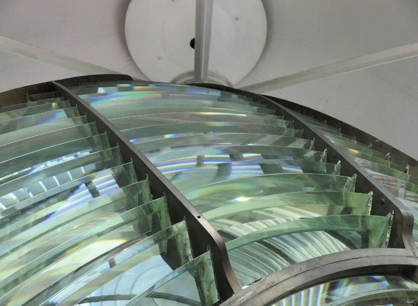
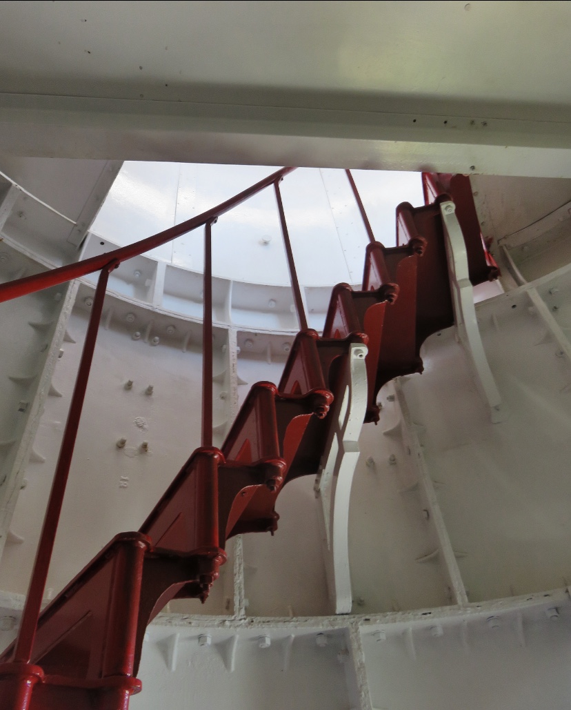
Standing at the tip of Cap-de-la-Madeleine, the eponymous lighthouse is a 17-metre high cylindrical tower topped by a circular iron lantern and a domed roof. It was built in 1908 and is the second lighthouse established on the site to guide commercial ships and assist local traffic, however since the year 2000, it no longer lights. It was designated a heritage lighthouse in 2016.
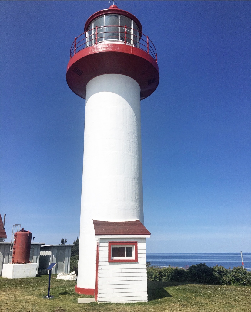


It is a privileged site where you can enjoy an exceptional view of the river and the cliffs. You can climb to the top, visit the museum where a guide-interpreter tells the legend of the place or go to the small café-boutique installed in the house of the assistant caretaker just next door, so it is an ideal place to take a break, relax for a few moments and admire the maritime panorama that surrounds you.
POINTE-À-LA-RENOMMÉE
My favourite lighthouse is Pointe-à-la-Renommée. After covering a few kilometres on an unpaved road, we parked and set off to discover this beautiful lighthouse with a rich history.
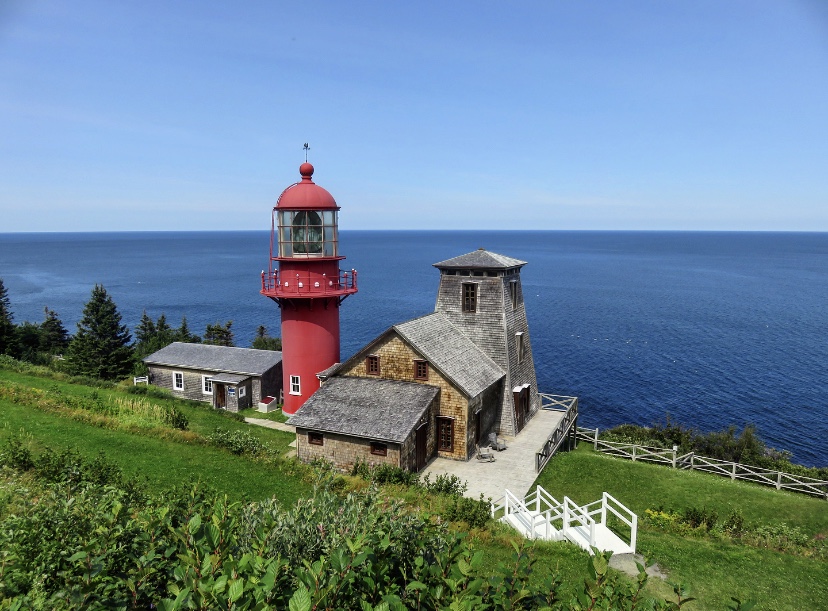
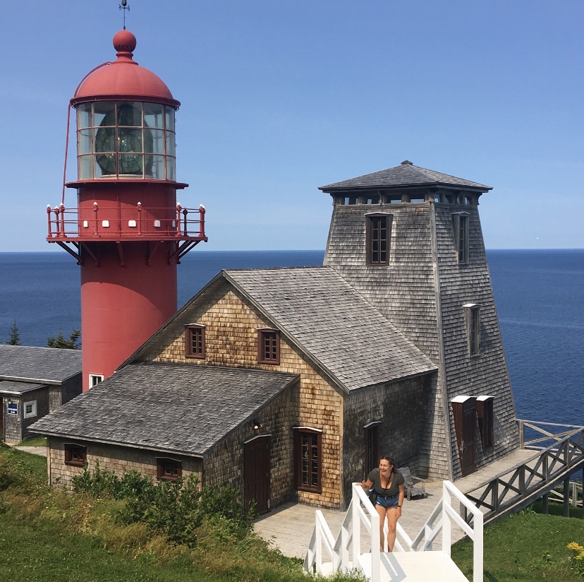

Now a historic site, the panorama from the lighthouse is grandiose and the wait for the guided tour went smoothly in the gardens overlooking the lighthouse. This beautiful lighthouse was deserted in the 1960s, dismantled and shipped to Quebec City in 1977. However, it was repatriated in 1997 by a mass appeal from the locals and was classified as a historical monument. Thanks to the guide-interpreter, we then discovered living inside the lighthouse, the life of the families who lived here and the heavy task of being a lighthouse keeper. It was really fascinating.


However, it was the visit to the small bunker next to the lighthouse that fascinated me, especially thanks to the information provided by the guide (otherwise there are explanatory panels in English and French, but the reading can quickly become boring compared to dynamic, lively explanations). In this bunker, you will discover an exhibition called “Marconi, the history of communications and radio”. You will have the opportunity to find out more about the captivating history of the first maritime radiotelegraphy station in North America and the life of Guglielmo Marconi, radio operators and optical signal (semaphore) operators.
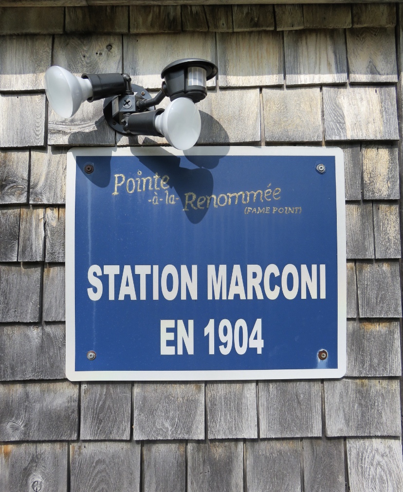
Indeed, it was in Pointe-à-la-Renommée that Marconi installed the first maritime radio station in North America, a place that would quickly become a strategic centre during the two World Wars. Taking this unpaved road from the main road, you can’t expect to come across two wonders that shaped history.
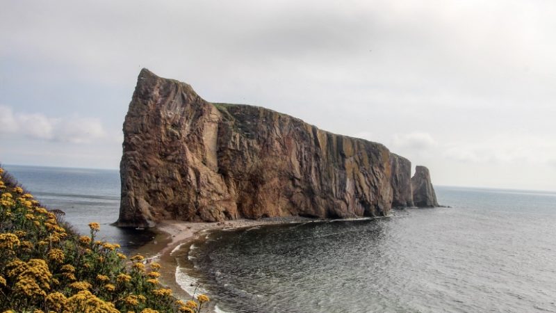
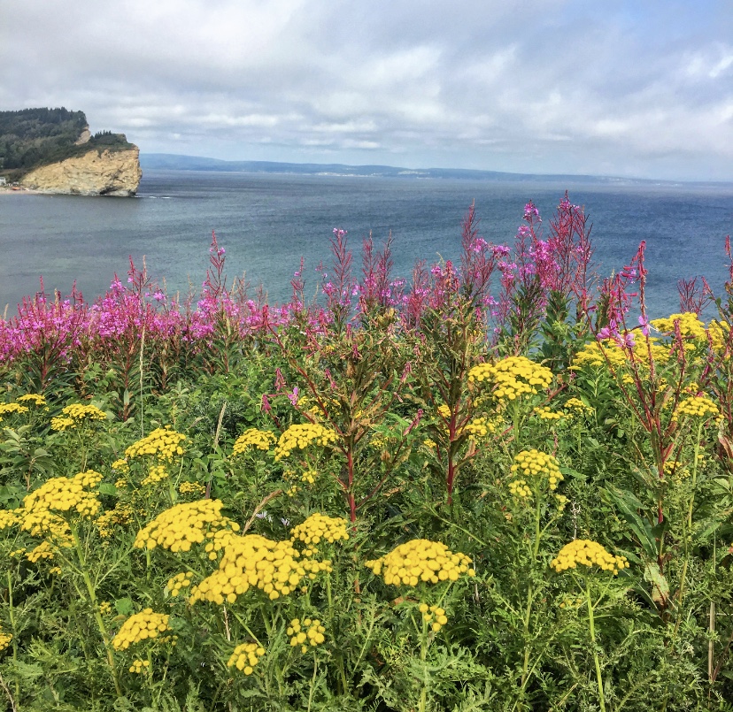
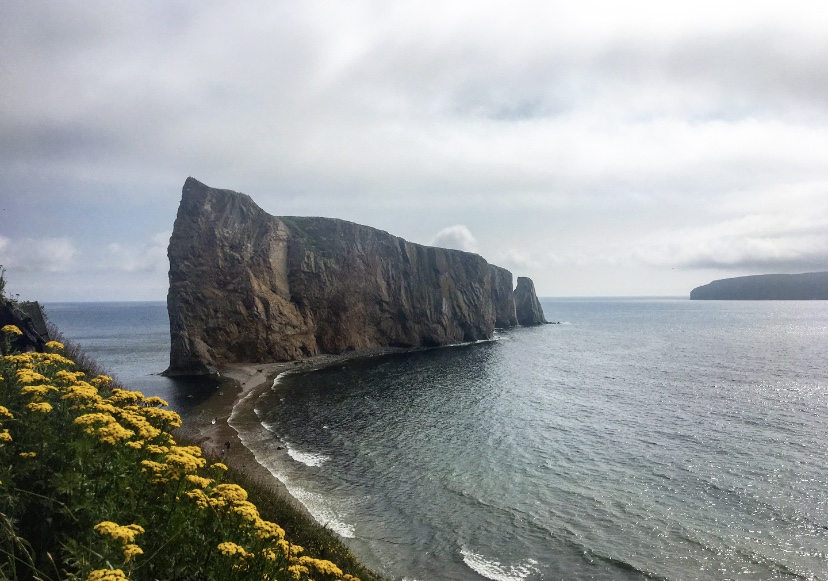
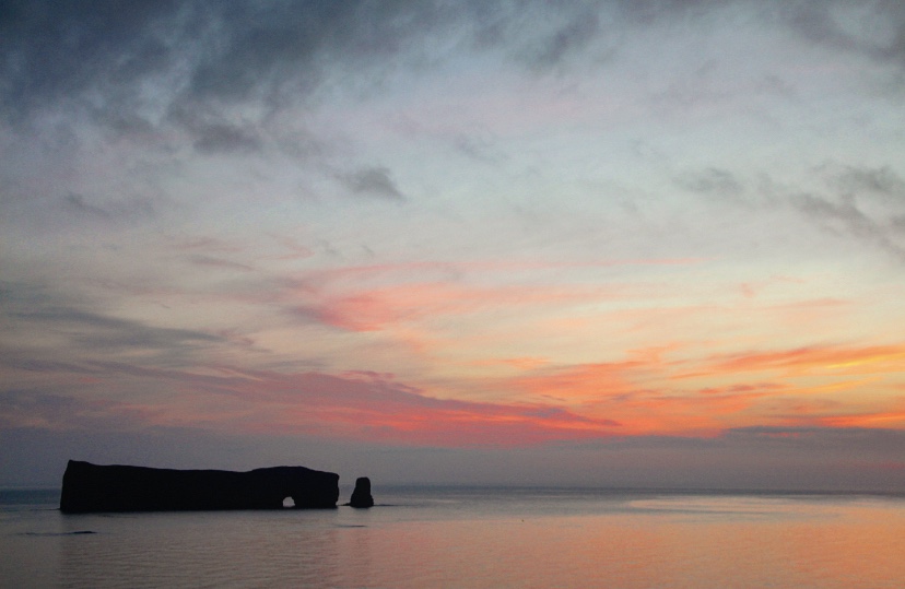
PERCÉ
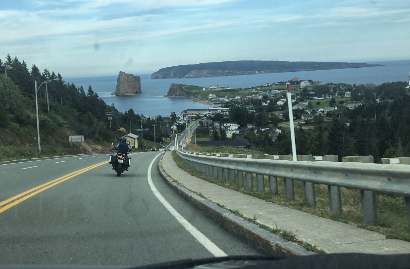
Arrival in Percé, a different view of the rock and the island
A must-see on a road-trip in the Gapésie, this wild and beautiful site owes its fame to its renowned rock. And when one says famous rock, it means, unfortunately, that it is under the influence of tourists. It is the most touristy place we’ve ever been to in the Gaspésie and it was impossible during the high season to find a hotel where the cost per night was no more than $200.
As a result, we decided to go Couchsurfing again, at the only resident of Percé who offered this option (in 2018, it may have evolved since then). A novel could be written about our adventures at his place for 2 nights and the story of our meeting with this gentleman is, by far, my best anecdote of this trip (maybe of all my trips). To make a long story short, and let you imagine what we went through, here is a range of keywords: yurt, doll’s house, hens, insalubrity, permaculture, suspicions of murder…

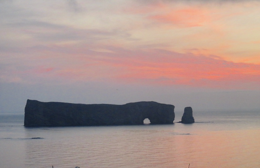
Before going to find out where we were going to spend the night, we vaguely wandered around the main street looking for information on what to do. Finally, it was my paper guide that gave us the idea of going to the Mont-Joli lookout (for $1) to get a close view of the Percé Rock.
It materialized in front of us and we understood the magnitude of Percé, thanks to this rock, the image of the Gaspesian Peninsula all by itself! Mont-Joli is a small cape of shale, more than 410 million years old according to the information gathered at the tourist office and it would have been connected to the Rock in the past.

We will end this day with a must-see stop on our Quebec road-trip: the local microbrewery. Here, it is called the Pit Caribou, and the atmosphere is friendly and the beers delicious.
If you want to get a closer look at the rock, you can also embark for Bonaventure Island to admire another great spectacle: that of the Northern Gannets, sea birds that come in large numbers (about 100,000) from March to October to breed and nest on the island’s cliffs. As a spectator, one has the impression of seeing a white down, even from the ocean’s edge, since we have not undertaken to go to this national park.
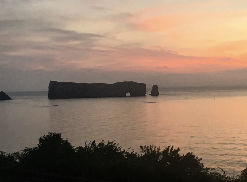
Before leaving for the rest of the Gaspésie, we had decided to get up while the night was still going on (and to leave as soon as possible from our host’s place, but shhh), to immortalize the symbol of the region at first light. It was there, resisting for decades, but also surrounded by a small mist that would not give the desired effect. Yet how beautiful it was!


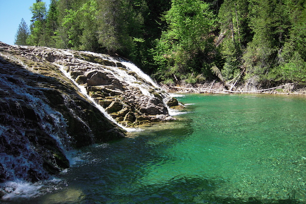
We heard about the Emerald River which is located next to Percé, during our Couchsurfing stay in Rimouski. We didn’t go there, but judging by the pictures of our hosts, it is clearly a place to visit, because of its beauty and to refresh oneself in the middle of August.
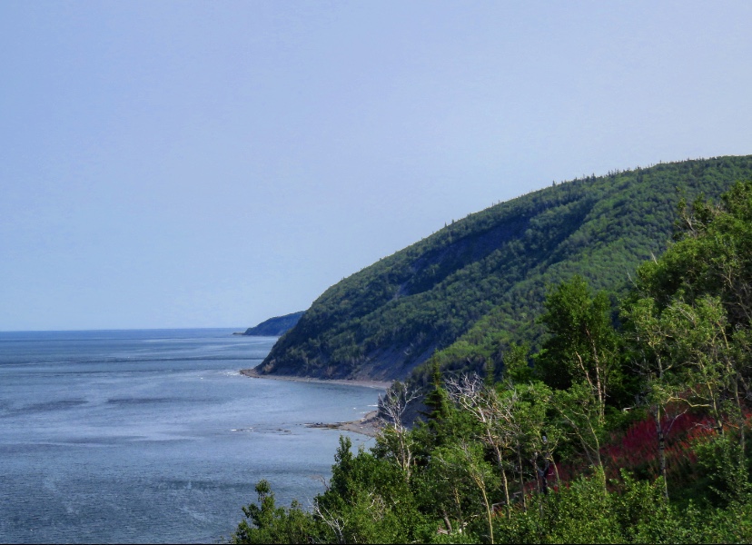
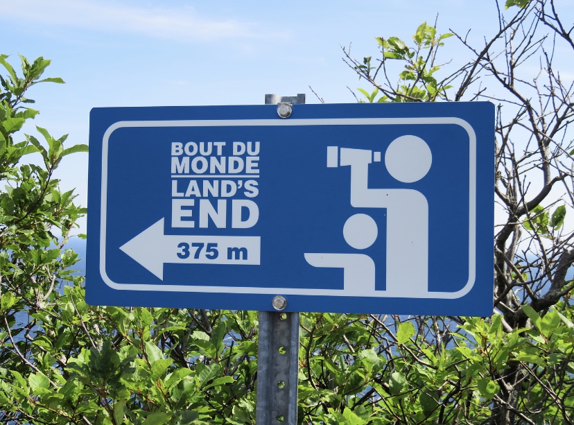
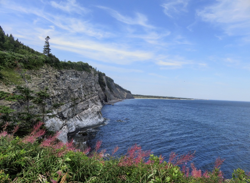
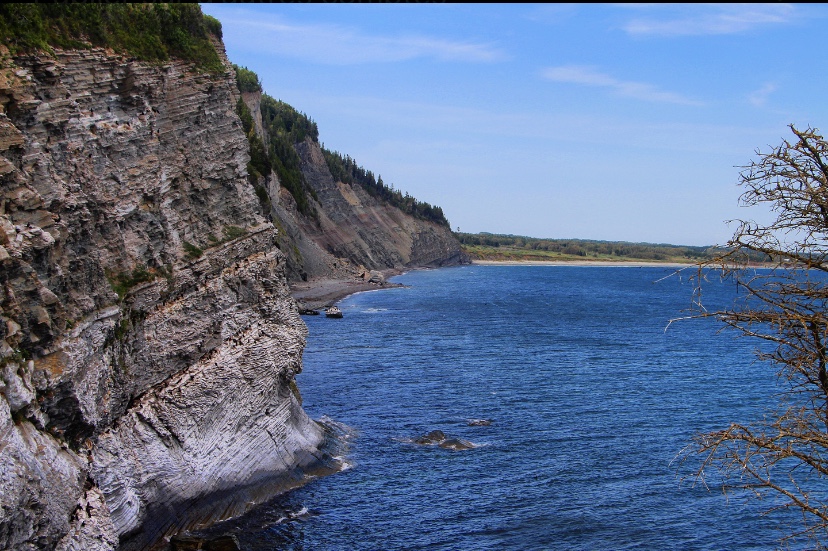
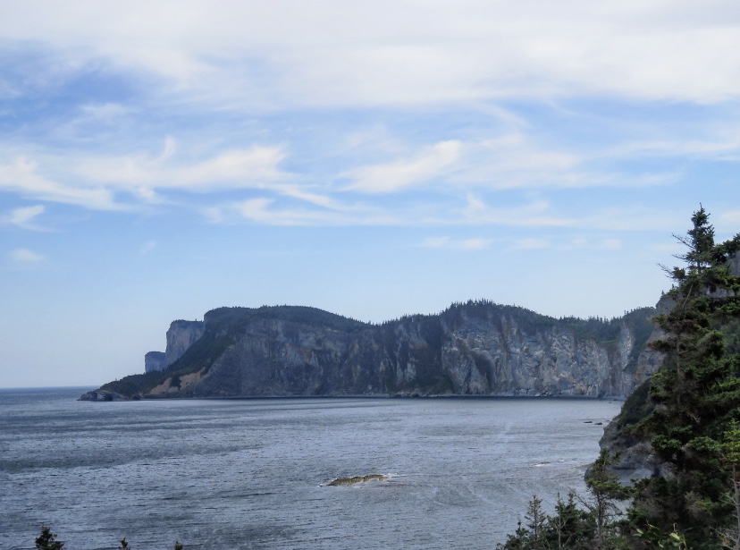
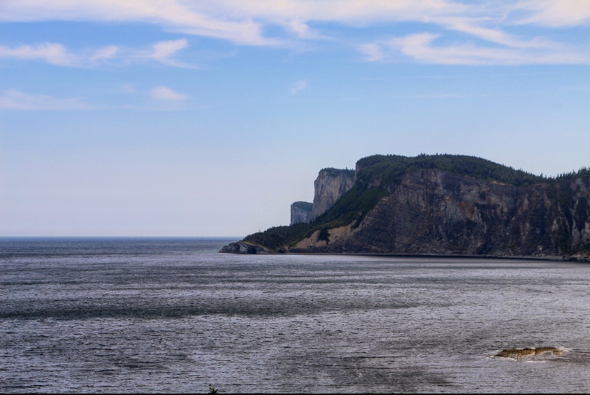
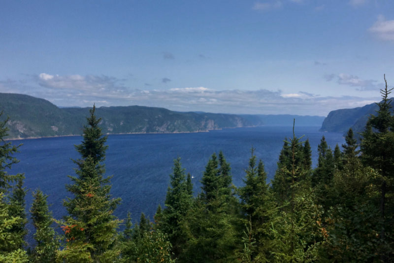
FORILLON NATIONAL PARK
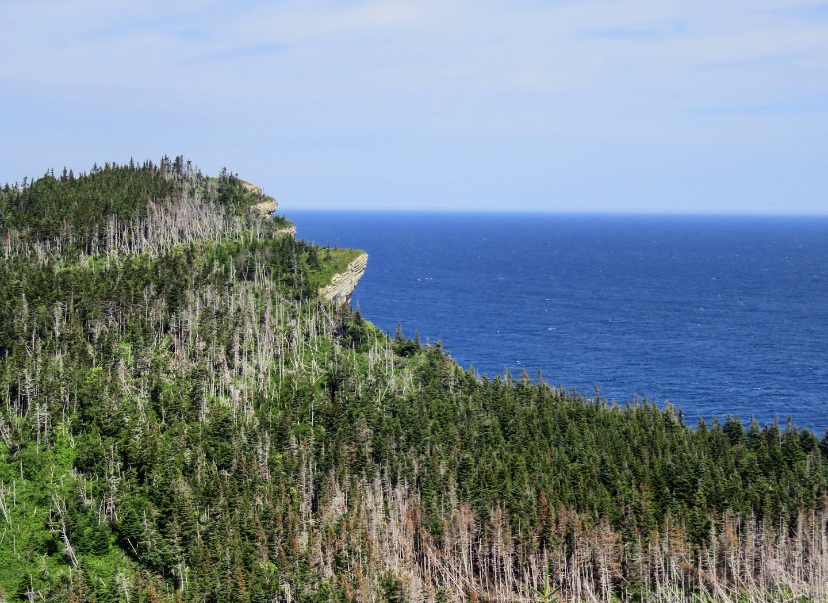
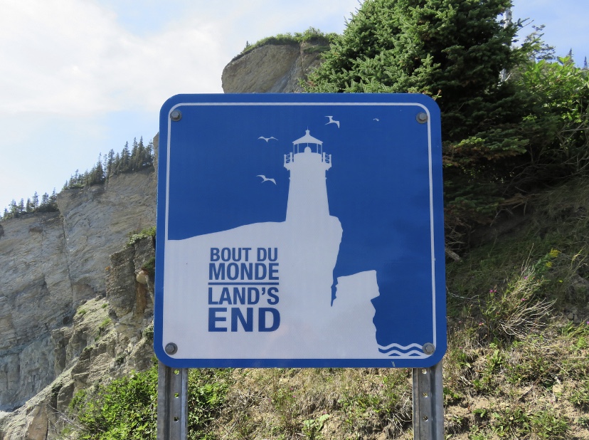
Clinging to the tip of the peninsula, this park is a vast natural space and clearly one of the most beautiful places in the Gaspésie! Between land and sea, these two elements intertwine perfectly and create magnificent landscapes. Here, everything indicates this famous end of the world that has been sold to us since we arrived in the Gaspésie. In fact, the extreme tip of the peninsula is located in the park and I will take you there further down in this article.
The park covers 245 km2 between the Gulf of St. Lawrence and Gaspé Bay. It is part of the Canada parks. It is, therefore, a national park and you will find information about it here.
The nature is green, wild and the wildlife incredible! If you want to see maritime landscapes between steep cliffs sculpted by the sea, pebble beaches, coves and capes, but also a particular forest since it is there that the famous Appalachian Trail ends, well, its Canadian extension, it is definitely at the park of Forillon that you have to go to!
Daily rate
In 2018, the price was $ 7.80 for an adult.
ACTIVITieS
We have inevitably gone in for hiking, the first way to discover all the diversity of the national park. As usual, we stopped at the Discovery Centre to see the range of hikes available to us. Having heard a lot about this famous end of the world, we wanted to walk to it. And then, we heard that we could see whales, many animals and especially bears.
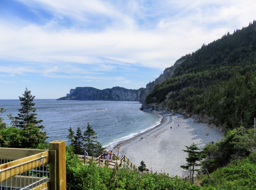
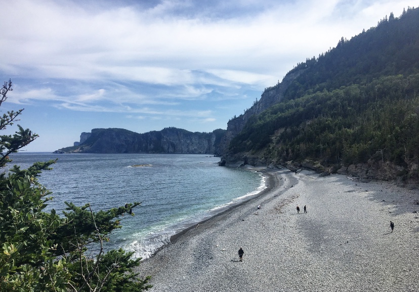
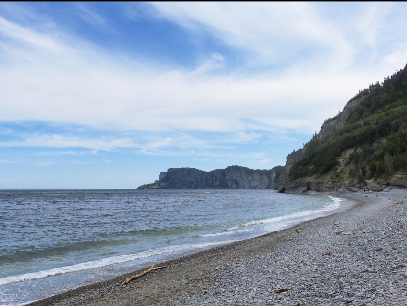
So, we decided to hike the Graves Trail (8 km return) that goes from the southern sector of the park to L’Anse-aux-Amérindiens, then continue through the forest, on the official path, to reach Cap Gaspé, the famous end of the world. This trail allows you to go along the Gaspé Bay, and to see whales, but as usual we will not see any animals.
We had arrived around 10:00 am when the park was starting to welcome numerous visitors. So it was not easy to find a parking spot at the beginning of the hike, but luckily we were able to park as close as possible, which saved us hundreds of meters on foot (everything is good to take, at your 5th park in a short time). And then, we could see a van fitted out by a family from Vaud (where I live in Switzerland) and to see this, awakened our desire to leave, one day, to live a nomadic life like this family.
Well, we put this dream in a corner of our heads and we started the hike, first on the path that cyclists can take. At the beginning of the hike, we were careful with the slightest noise as we thought we were dealing with bears! And yes, when we read in the park guide that the black bear population in Forillon was stable, we were impressed by the numbers and happy to see that this animal thrives in the park (it lives in total freedom), then the statistics said that there are about 3 bears/10 km2, and that’s when we started to get the shock of meeting one.
However, it could have been an intriguing opportunity to discover this emblematic animal in its natural habitat. According to the rangers at the reception, he’s easy to see because he doesn’t hide from people. However, as we are dealing with a wild animal, moreover on its territory, a few recommendations are to be read before undertaking a hike in the park. I put these below:
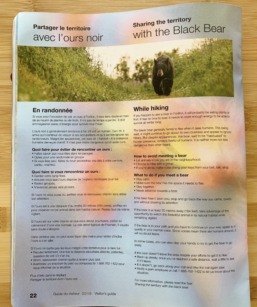
So, after reading this, to avoid coming face to face with a bear, we started singing to make noise. Well, we thought that we were a bit ridiculous, that the bear, if we came across one, wouldn’t hurt us, that it would even be incredible to come across one, etc. so we went on our way, talking normally. We ended up leaving the road, to take the path on the cliff, which runs along the Gaspé Bay.
Along this path, there is a possibility of observing marine mammals, but just like bears, we will not see any. However, with each slight movement in the water, we were on the lookout, hoping to see a whale or a rorqual whale.
The path allows for a leisurely walk to L’Anse-aux-Amérindiens, where we left the ocean shore to venture into the forest. I was very excited because I was taking the International Appalachian Trail (IAT) as soon as we left the ocean to venture into the forest. Since 2015, a long-distance hiking route (GR) has been integrated into North America: the GR A1. Indeed, this international trail links the one simply named Appalachian Trail, which is about 3’510 km long and entirely in the United States. The section we took connects Mount Katahdlin, in the American state of Maine, to Cap-Gaspé, our final destination.


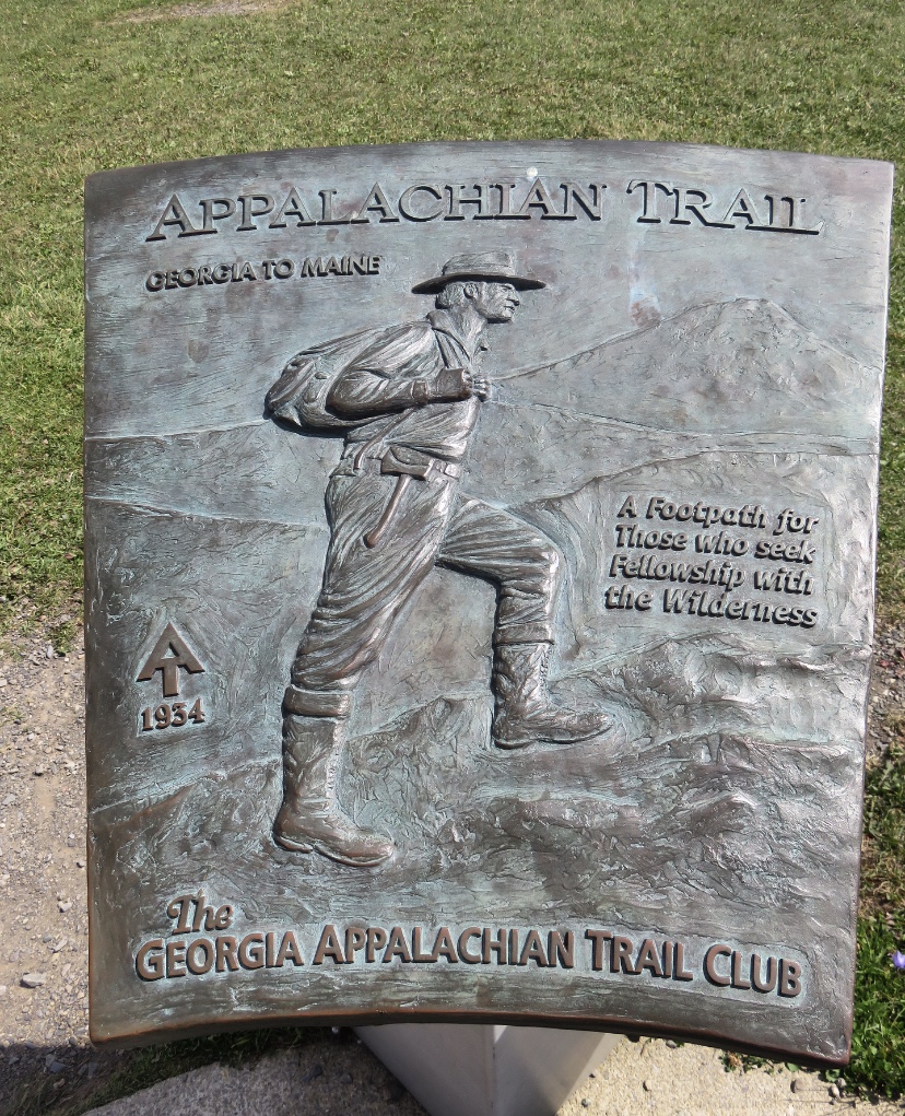
After devouring Cheryl Strayed’s book Wild (about her adventure on the Pacific Crest Trail, another hiking legend) and especially Bill Bryson’s A Walk in the woods (about his Appalachian Trail adventure), I thought it was crazy to be able to walk on a world-renowned trail, knowing that I would like to do it one day as well.
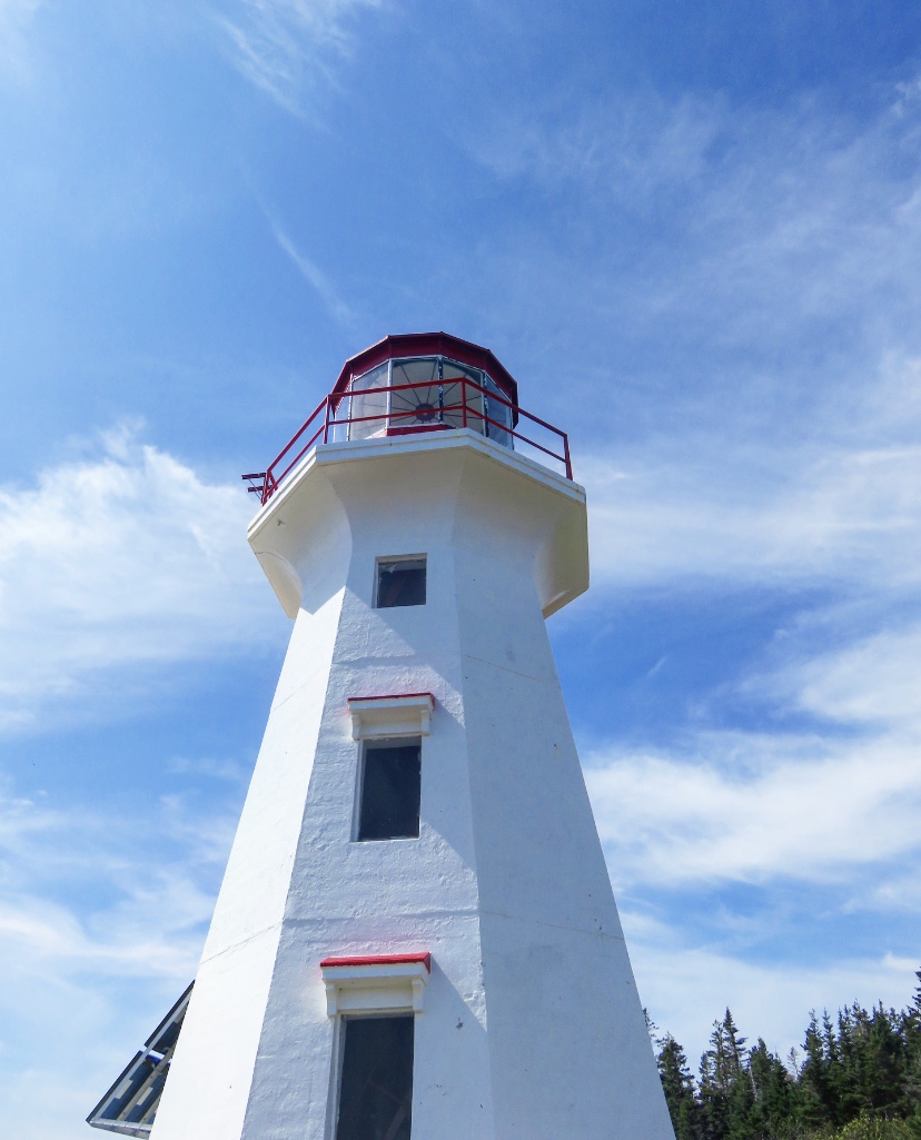
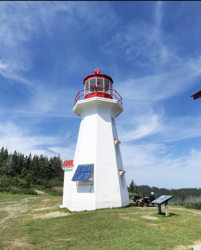
So let’s get back to the trek. We finally arrived at the Cap-Gaspé lighthouse which is splendid, red and white, and measures 12 meters. We made a small stop to eat and then we took the road again to reach: this famous end of the world.
As we were descending, we began to feel the speed and violence of the wind, and on the Belvedere, it was even worse. But what a panorama! Even if we protected ourselves from the wind, the view was incredible on the cut cliffs, on this majestic ocean and on all these birds flying (or trying to regarding the wind). Another magical moment to capture with her eyes before going back up, to begin the way back.

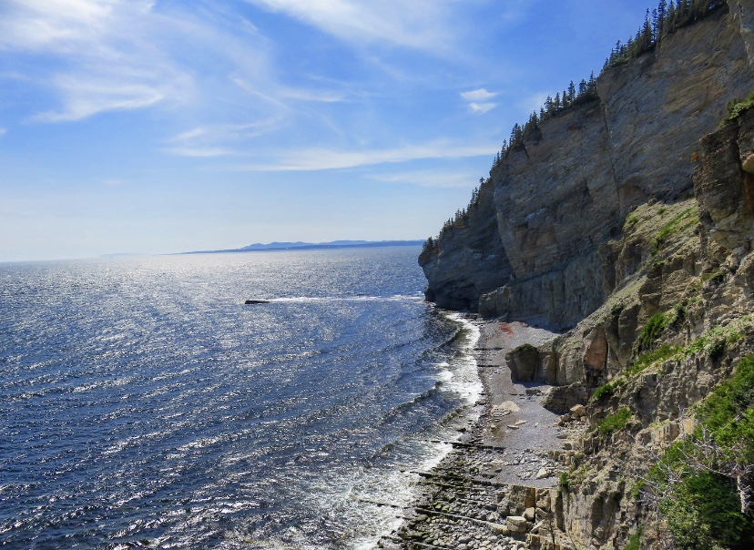

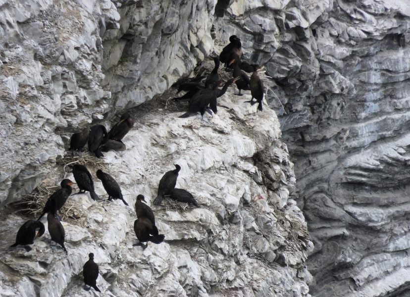
Having still some time before going shopping to make dinner for our host, we decided to go to the northern sector of Forillon Park, to see the cliffs of Cap-Bon-Ami. This place is famous for its magnificent sunsets, but also for representing this sea and cliff show where animals are the stars. Naturally, apart from hundreds of birds that I could not name, we did not see any animals. But the panorama is incredible with a huge pebble beach and steep and majestic cliffs. Really take the time to contemplate this landscape.


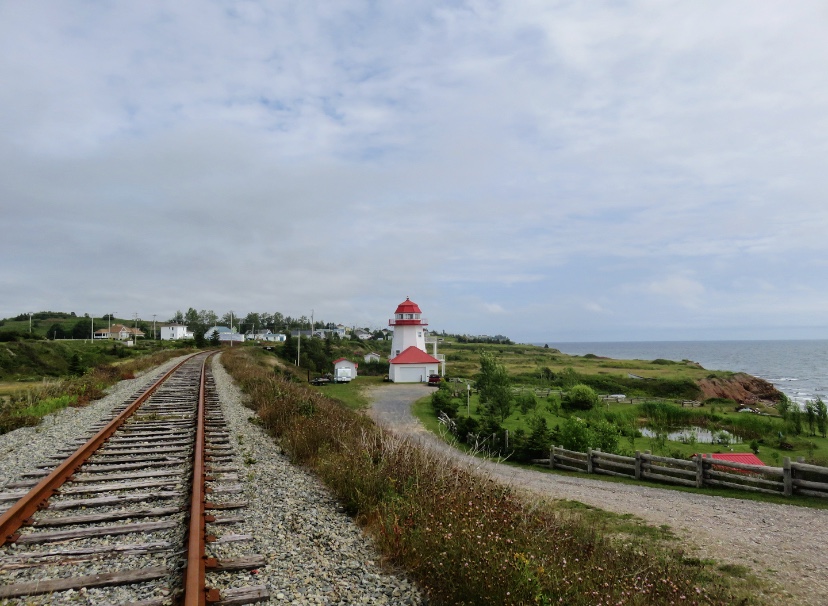
Returning by the northern road, just outside the park, we passed by Cap-des-Rosiers and its magnificent lighthouse which is also worth the trip. It is the oldest lighthouse in Gaspésie and especially the highest in Canada with its 34m.


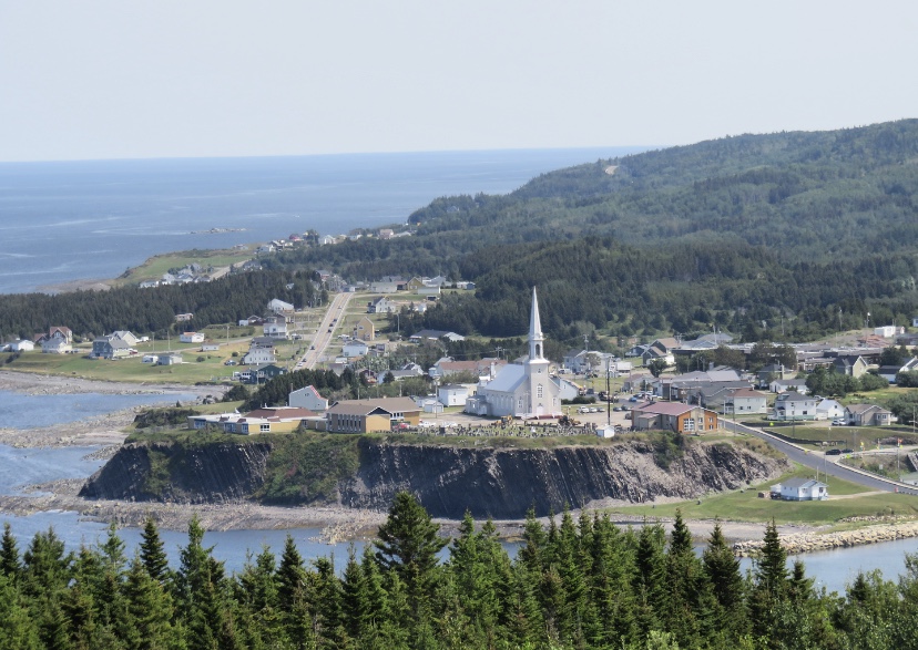
On the way back, we make a stop in Gaspé, a town known mainly for being the place where Jacques Cartier planted a cross in 1534 while “discovering” Canada under the aegis of the King of France. However, there was nothing special for us to visit and we were in a hurry to buy food.
route BETWEEN PERCÉ AND CHALEUR BAY
The road is not the most picturesque and we began to regret spending a night in Carleton-sur-Mer since we could clearly have continued the journey to Rimouski in the Bas-Saint-Laurent. The weather wasn’t very helpful either and as a result, we discovered a few beautiful places, but none particularly extraordinary.
L’ANSE-À-BEAUFILS
It is one of the must-see sites of the Great Percé, especially because it has become a renowned cultural site (in Quebec anyway). The villagers have metamorphosed an old cod processing factory into a cultural centre. In fact, this place is called “La Vieille Usine” and is now an auditorium, an art gallery, and many other names are added to its description to make it a place of creation and interpretation. The harbour is pretty and gives a picturesque charm to the place, but when we stopped early in the morning, it was all at rest.

CHALEUR bay
After a monotonous trip from Percé, we discovered a completely different aspect of the Peninsula in the Chaleur Bay region. Here, people come mostly because of its vegetation and its various rivers that provide many activities. The water is not warm, but the name Chaleur comes from the words Jacques Cartier pronounced during his discovery since a mist enveloped it and left a false impression that the water was warm.
Legends vary since, according to the official brochure of the region, Jacques Cartier gave this name to the bay because it is warmer than the land of Spain, but it should also be noted that he landed during a period of a heatwave. The Chaleur Bay is also a member of the “Most Beautiful Bays in the World” club (like Tadoussac).
Chaleur Bay is a group of resort villages and, since it was difficult for us to find an activity to do, it was an opportunity for us to rest and learn more about the Acadian culture and heritage of the region (thanks to Wikipedia).
NEW RICHMOND
We walked for a few minutes in the Point Taylor Park, however, the weather was mostly rainy, so we could not see the rest of the town, which owes its existence to settlers who remained loyal to the British Crown after the independence of the United States. As a result, there are several influences: Irish, Scottish and also an Anglican church.
BONAVENTURE
We stopped in Bonaventure since its eponymous river is renowned for its crystal-clear waters and numerous activities. However, it was impossible to get close to it since many of the surrounding areas are salmon fishing reserves, or mini-villégiatures where you have to pay just to get in.

So we fell back to the Acadian Museum of Quebec, however, for a reason that I can’t explain today, we didn’t visit it. I strongly advise you to visit it if you go through Bonaventure because this town was founded by Acadians in 1760, and the whole Chaleur Bay breathes Acadia. Cultural events, vocabulary, different accents (we still haven’t fully understood our conversation with our two hosts), it’s a culture that deserves to be discovered and exposed!
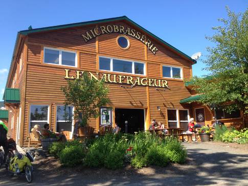
CARLETON-SUR-MER
A famous seaside resort, we had chosen to spend the night there when we were planning our itinerary. Unfortunately, we did not discover a seaside atmosphere but rather an old-fashioned one, obviously still surfing on its past reputation.
Consequently, before we could check in with our hosts, we spent the late afternoon at the microbrewery Le Naufrageur. Just for this place, with its delicious beers and incredible nachos, I’ll tell you to stop in Carleton-sur-Mer.
Although the city did not leave us with great memories, our hosts, at the Oiseaux Migrateurs B&B, let us discover a little more of the Acadian culture of the region and its history, and this around a good breakfast (included and delicious) prepared by David. We highly recommend this address, the rooms are large, clean and very comfortable, especially after our two nights and our crazy Couchsurfing adventures spent in Percé, this place was a dream. Just bring mosquito repellent because Quebec bibittes are voracious around this B&B! We went through Airbnb to find this gîte, you will find the address here.
West of Carleton-sur-Mer, you will find a very interesting national park, especially if you have a passion for fossils. It is the Miguasha national park and it is the smallest of the Sepaq Quebec parks. It has even been a UNESCO World Heritage Site since 1999. But we had a long drive to Rimouski, so we didn’t make it.
the VALLey
This region is world-renowned for salmon fishing in the Matapedia River, which meanders for over 70 kilometres. The eponymous lake can boast of being the largest freshwater body of water in the entire area of Gaspésie. Its plains and landscapes invite you to discover nature in a more authentic atmosphere where salmon and maple are the keywords.
The Valley is above all a 150 km natural corridor between New Brunswick and the St. Lawrence, our next stop. We thought we’d never see the end of it since we were on the verge of running out of gas. Even though we were very careful, knowing that the distances are long and gas stations scarce in comparison, we didn’t foresee this incident since our GPS indicated a station, but which had clearly been abandoned for many years. Fortunately, we found one while the car’s reserve was almost empty. We heard a lot of stories of Canadians facing fuel problems, so be careful to always have a reserve!
SAINT-ALEXIS-DE-MATAPÉDIA
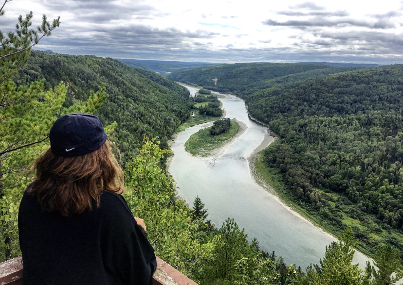
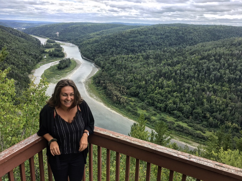
Saint-Alexis-de-Matapédia is known for the abundance of maple groves, but if we turned towards this municipality, it is to go to the Dream Horizon viewpoint. To do so, you have to leave Route 132 and take Rang St-Léonard to reach the town, then you will have to turn left (if you are coming from Matapédia) to take a 4km trail, Rang St-Hermel Sud, which will take you to the lookout. You will then have to walk a few minutes (about 1km round trip) to discover a magnificent view.
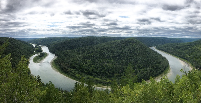
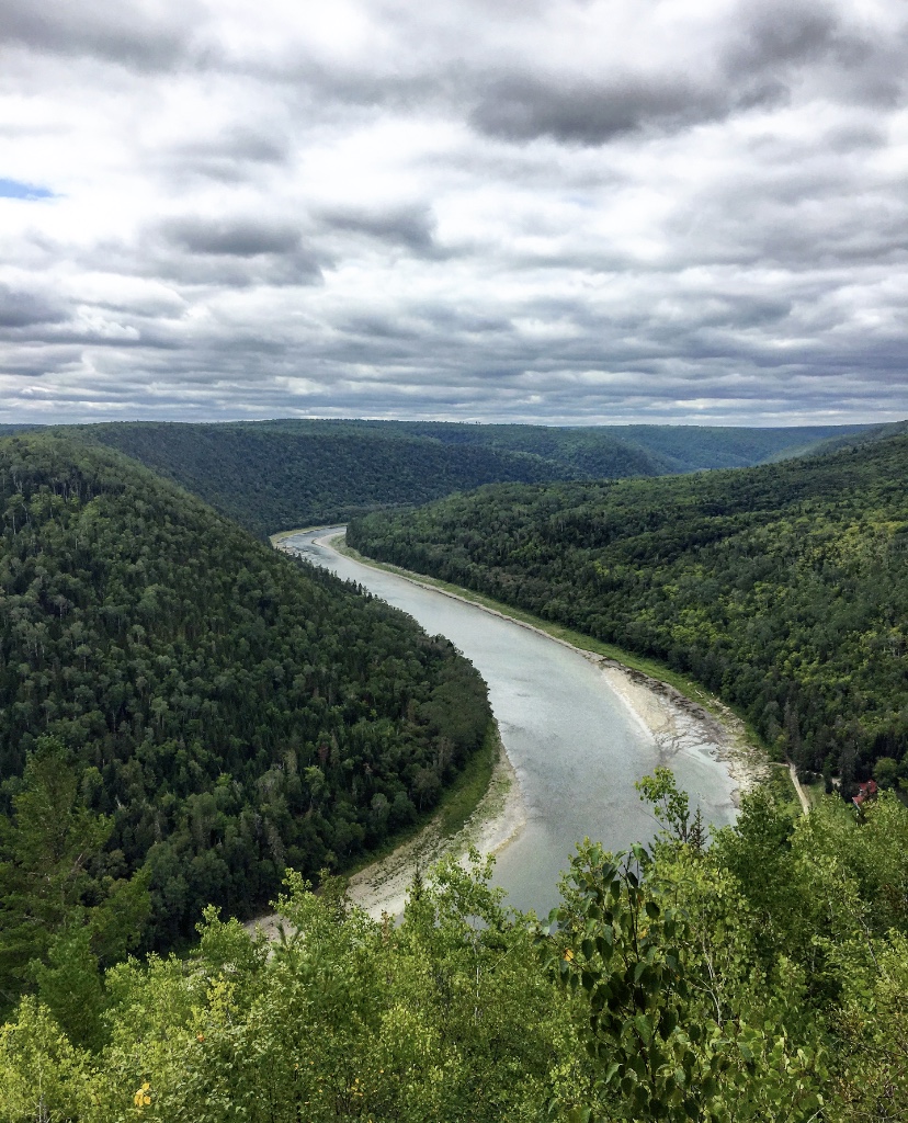
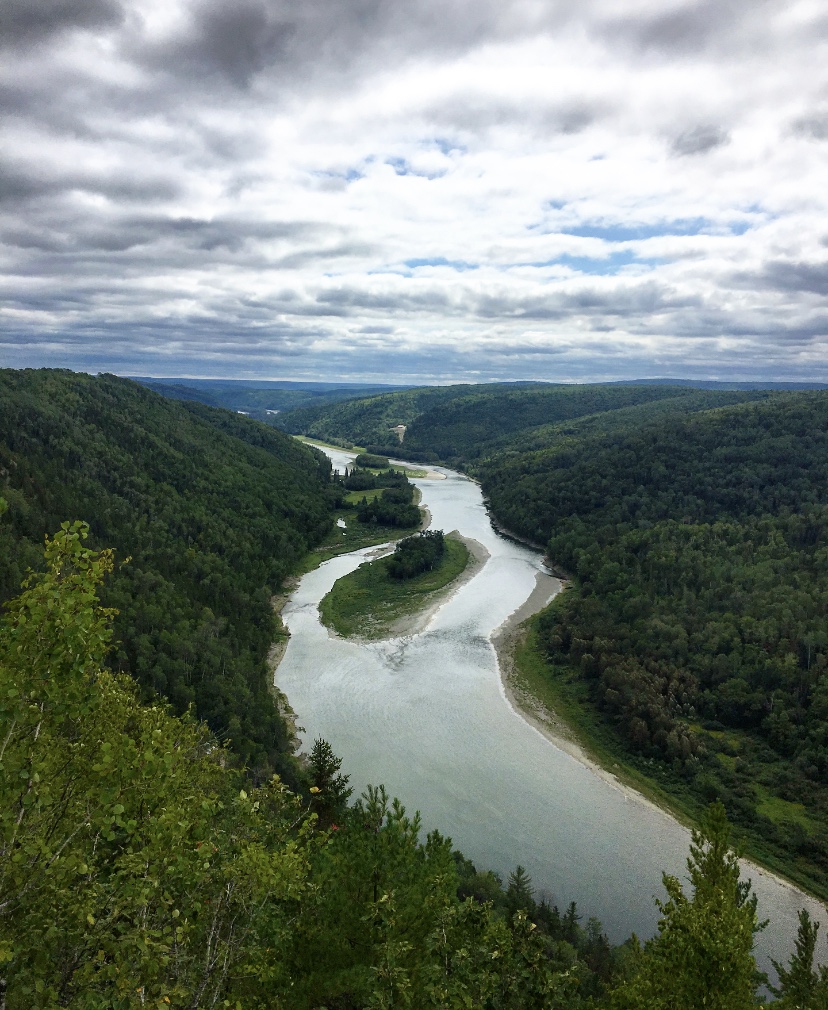
This view took us to a panorama that stretches across New Brunswick, so your phone may be taking the time of this Canadian province (1-hour difference). Under your feet flows the Restigouche River which makes its way through an ocean of forest. We thought that this view must be even more impressive in the Indian summer, with the shimmering colours of the leaves.
SAINT-ANDRÉ-DE-RESTIGOUCHE
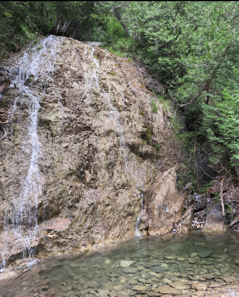
We still had a little time left before taking Route 132 back to Rimouski, and as we stopped at the tourist office in Matapedia, we discovered that there were various walks in the area to reach waterfalls. We chose to see the Chute à Picot.
To reach it, you have to go back on route 132 and then take the Lagacé road on the right which will take you to Saint-André-de-Restigouche. However, before reaching the village, you can stop at an observation tower, which was closed during our visit. You will have to continue a little on the road and then take a trail, Rang Petit, on the left to get closer to the Falls. From this point, you can take the International Appalachian Trail. It is an easy trail of about 3 km round trip with a long series of wooden stairs. It is a nice walk in the forest, and we were expecting a nice waterfall, but it was rather dry at that time.


The Gaspésie is a region of Quebec that is still relatively unknown internationally but is very well known to Quebecers who love to go there because of its nature and its very maritime aspect. I clearly did not expect to discover a region rich in cultures, landscapes and ultra-friendly and warm inhabitants. I would definitely go back there one day…


Comments (1)